This Friday 6:30-8:30 am: Bike & Truck Safety Fair

Share the road safely! Join the Port of Seattle and  partners for an opportunity to learn about truck blind spots and the challenges bicyclists and truck drivers face each day as they share Seattle’s busy roads.

Come for bagels, fruit and coffee. Stay to ride along in a semi on a short course to see what truck drivers can and can’t see. 15 minutes at the Bike & Truck Safety Fair may give you a new perspective, and an opportunity to meet SDOT, WSDOT and Port of Seattle representatives.

When: Friday, September 6, 6:30 a.m. to 8:30 a.m.
Where: Terminal 25, 3225 East Marginal Way, south entry, just north of Spokane Street, where the truck drivers park

Bike_Truck-Fair_Flyer_final_2-1We are partners of this Port of Seattle sponsored event. if you would like to volunteer an hour, we could use one or two more.


East Marginal Way – interim improvements

The West Seattle Blog reported this week on interim improvements for East Marginal Way S from S Spokane St to S Atlantic Street (at the Coast Guard’s Pier 46).

In addition to the improvements listed by SDOT, we have asked for
– removal of fire hydrants that are right in the middle of the path. These violate SDOT, SPU and ADA standards.
– widening of the path/sidewalk to make it safe and usable for high volume 2-way bike and low volume pedestrian traffic, with safe room for passing.
– improvements to sightlines at some of the terminal driveways where fencing, signs or other obstruction interfere with views.

It will be a tough sell to get the bike commuters currently using the northbound bike lane to switch to the sidewalk on the west side unless it is really improved to be a safe, smooth bike path with room to pass safely.

trees in "tree pits" and hydrant obstructions
trees in “tree pits” and hydrant obstructions

trees in "tree pits" and hydrant obstructions
trees in “tree pits” and hydrant obstructions
trees in "tree pits" and hydrant obstructions
trees in “tree pits” and hydrant obstructions
sign could be raised up to avoid obscuring sight triangle at drive.

Bicycle Loop Detectors

WSBC heard that some people don’t know that the Seattle Department of Transportation (SDOT) added bicycle loop detector markings at many intersections. These markings indicate where cyclists should stop in order to trigger a green light at a signalized intersection.

The marks can be seen as one pulls up to a red light, so as long as there are no motor vehicles in front of you. The marker will generally be located behind the white stop line and generally slightly to the right, positioned over the vehicle sensor that’s embedded in the pavement. There are two forms we see most regularly; the older “T” marking or the newer small “bicyclist” marking, seen here.

loopdetectorPortland

Simply make sure your front tire, at least, is centered over this white marker and you should be added to the signal rotation.

loopdetectorbike

Some intersections don’t have this marker, or they may be faded away. If you think a specific intersection should have a marker but doesn’t you can contact walkandbike@seattle.gov and let them know.

Some intersection signal phases are triggered by camera, not a pavement marker, and these are trickier to identify. If you are not picked up when using a loop detector marker, the light skips you on a regular basis, takes an inordinate amount of time to change, or you need more information, you can contact SDOT at the email address above. Reporting signalized intersections that don’t pick up waiting cyclists should be fixed quickly to help prevent impatient red-light running and general cyclist frustration.

Another Collision – Let’s Stop This

Once again, flashing red lights on East Marginal Way. Medic 1, Rescue 1, Ladder 7 and a bike rider on a backboard. This time, bike-on-bike collision. Second one within weeks. Thank you Scott Johnston for this report on Bikewise.org

This was not an “accident”. This was negligence. The one who caused it walked away. The one who was riding correctly in his lane got a trip to Harborview. I hope the injured rider [edited] receives full restitution from the rider who caused the injury, and that the one who caused it is charged with negligent driving and penalized under the new Vulnerable Users law if the injured rider’s injuries are substantial.[end edit]

We need to get to work safely. We need to get home safely. Commuting to work is not a damn race. No one cares how many riders you pass or if you get downtown 2 minutes faster. If you want to race, sign up for a race and stop pretending. Riding to work or home relaxed and alert has all kinds of benefits.

How about trying some of this?

Stay alert.
Be aware of what is in front and beside and behind you. Watch your line. Keep your hands near your brakes.

Ride in a predictable manner.

Share the road.

Leave space between you and others, so you can see what is ahead.

Don’t pass unless you can see well ahead that the way is clear.

Call out your passes before you pass, or ring a bell. When it is crowded or you can’t see ahead, SLOW DOWN and communicate.

DB

Bike Master Plan Update Comments / Deadline

Deadline for public comments to SDOT is this Friday, July 26.
Seattle Bike Master Plan Update
West Seattle Bike Connections submitted group comments last December. We met twice as a group with SDOT staff, participated in the public workshops, and just submitted detailed comments and a “report card” on the changes made in the June 2013 draft compared with the December 2012 draft.

SDOT bike planners, traffic engineers, and their planning consultants at Alta are working hard to make this a world-class plan for bicycle transportation. We appreciate their good work. But they don’t know every aspect of the city, and that’s where we come in. If you send your own comments on areas important to you, we will give West Seattle a strong voice in this important planning and policy document.

A plan does not guarantee that the planned improvements and programs will be funded, but if something is not included in the plan, it will be much less likely to ever be budgeted by the Mayor, funded by City Council, or implemented by SDOT.

WSBC_2013BMPDraft_ReportCard

121213-WSBC-SDOT-SW-lg

Sunday July 14 West Seattle STP – Seattle to Portland in one Morning

Updated 7/9/13

REASONS TO RIDE WITH US ON STP WEEKEND (Sunday, July 14th):

  1. Didn’t make the 14,000 rider cutoff for Cascade Bicycle Club’s Seattle to Portland ride.
  2. Can’t imagine why anyone would want to ride a bike 200 miles in one or two days.
  3. Have never left the peninsula and see no reason to start now. “We have everything in West Seattle”.
  4. Don’t really know anyone in Portland.
  5. Portland think they all that, but they ain’t.
  6. Like to sleep in own bed instead of on a baseball field in Chehalis, or at least with a good friend with a nice bed and indoor plumbing.

So, COME RIDE West Seattle STP WITH US!

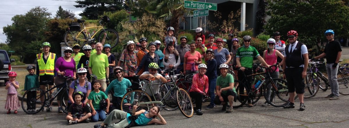
Family friendly West Seattle Bike Connections ride supported by West Seattle Spokespeople and Cascade Bicycle Club.  Ride from Seattle to Portland and back in just 1 morning!

Meet on Sunday (7/14) at 9:45am at Hamilton View Point on California Ave SW to sign in, and be ready to roll at 10:00 on a 9.5 mile easy pace ride via proposed Greenway routes from SW Seattle Street in the Admiral Neighborhood to SW Portland Street in the Fauntlee Crest Neighborhood.

Experienced, certified ride leaders Stu Hennessey and Marge Evans will keep the group together and ride at a social pace. No one left behind. Ride continues on from SW Portland to California and Alaska (the West Seattle Junction, that is) to join the West Seattle Summer Fest. We’ll be at the Greenlife Stage for post ride discussion or routes and bike riding improvements proposed in the Seattle Bike Master Plan update.  Helmets required. This is a Cascade Bicycle Club sponsored ride.

No fee, no t-shirt, no medal, and no bagels with peanut butter, but we stop at a fabulous festival with street food vendors, live bands, arts and crafts!

Riders under 18 years of age must have a parental consent release form, riders under 15 years of age must be accompanied by a parent and riders under 8 years must be on an assisted vehicle, tag along, cargo bike or a bike trailer.

We need volunteers! Please sign up below if you would like to help with this ride. We are looking for some people to act as crossing guards at intersections, making it safe for all ages and abilities to cross.

[iframe src=”https://docs.google.com/forms/d/1-vIWfQuM0MMcL8YNJxIN_5K9goiBndFjR9mnz620bqc/viewform?embedded=true” width=”550″ height=”500″]


State Transportation Funding & West Seattle Bridge Trail

This received today from our West Seattle state Representative Joe Fitzgibbons. Thank you, Joe!

“Thanks for reaching out to let me know how important transportation safety programs are for you and for our state.  The House passed a transportation package today that includes an amendment I sponsored to put $16 million in pedestrian and bicycle safety projects around the state.

“One of the projects is an investment of $500,000 that will be provided to make improvements to the West Seattle Bridge Trail, making this commonly used, but dangerous, route safer and more accessible for the many folks who right now are risking their lives using this trail.

“While it is unclear what will happen to this bill in the Senate, I will keep working towards its final passage and try to hold on to the pedestrian and bicycle safety funding that is in the current transportation package.

“Thanks again for contacting me and please feel free to keep in touch with your questions and concerns.

“Take care,”

Joe Fitzgibbon
State Representative
34th Legislative District
Joe.Fitzgibbon@leg.wa.gov

Bike Master Plan – Test Questions

Test questions revealed in advance of SDOT’s June open houses!

REPORT CARD     June 2013 Seattle Draft Bicycle Master Plan Update for SW Sector           

This is what we asked SDOT to add to the first draft of the plan update, in December 2012.

(this is not everything in the draft plan — only what we thought was missing last fall.)

How does the June 2013 draft respond? Attend an open house, then let us know!


# Description Notes Grade
1 East Marginal Way S / Alaskan Way S from S Spokane Street to S Atlantic St:  separated cycletrack or off street path     
2 SW Avalon/ Fauntleroy Ave SW, 35th, 36th & 37th Ave SW: intersection and bike lane or cycle track improvements, and add route on 36th Ave SW from SW Avalon to SW Alaska     
3 Connection on East Marginal Way S. from S Spokane Street to Diagonal Way S, Off road path or cycletrack needed on west side of East Marginal Way S.     
4 Fauntleroy to SW Morgan St. via 38th Ave SW: Enhanced street.     
5 Fauntleroy, from SW Alaska to California Ave SW “in-street, major separation”. At least bike lanes both directions of travel.     
6 Greenway route to east of California Ave SW from SW Holgate to Ferry Ave SW via 40th, Walnut SW, 41st SW or 42nd SW.     
7 North Delridge Greenways: add E-W connection at south end of Greenway on 26th Ave SW.  Bike ramp or runnel at steps.     
8 “Brandon Green Super Highway” three new bike/pedestrian staircases or paths along currently unimproved sections of the SW Brandon St. right-of-way: between 16th & 17th SW, between 21st & 23rd SW, and between 30th & 34th SW     
9 SW Portland St:  Extend the Greenway to the East to reach 9th Ave SW (top of SW Highland Park Way)     
10 SW Trenton from 9th Ave SW to 35th Ave SW:  bike lanes or Greenway.     
11 24th Ave SW from SW Cloverdale to SW Thistle: Greenway.     
12 Highland Park Greenway and Westcrest Park trail, and connections into campus of South Seattle Community College, with further Greenway/Trail route to north.     
13 West Marginal Way SW, south of SW Michigan to 2nd Ave SW: Major separation or cycle track.     
14 S Horton Street in SODO from East Marginal Way S to 4th Ave S. – minor in street separation or enhanced street with safe crossing at East Marginal Way S     
15 SW Andover from Delridge SW to 22nd Ave SW: connect 21st Ave Greenway and Delridge Trail from West Seattle Bridge to routes to west via Andover.     
16 37th Ave SW between SW Hudson and SW Alaska: an “enhanced street”     
17 Delridge SW to SW Holden –  Add a trunnel up the stairway.     
18 West Duwamish trail through South Park – coordinate with King County portion to connect with Seattle     
19 Extend the off-street West Marginal trail into South Park along S. Portland St. Cross Holden at the WA-99 light, use WSDOT right-of-way to connect to S Portland St, and add an off-street trail along Portland to 8th Ave S.     
20 Greenway route along Duwamish River in South Park: Connect the West Duwamish trail to the 14th Street Bridge via S Kenyon St, S 10th Ave, and Dallas Ave S.     
21 SW Admiral Way westbound (uphill) from Spokane St/ Avalon/ Harbor Avenue SW:  Improve connection for access to Admiral.     
22 Beach Drive SW into north end of Lincoln Park multi-use path – add connection.    
23 West Marginal Way SW and Highland Park Way SW: Redesign Northwest corner of to avoid collection of dirt and gravel.    


East Marginal Way – with SDOT

Notes from May 17 meeting at Seattle Department of Transportation

Attending from SDOT:

Dongho Chang, City Traffic Engineer

Monica DeWald, Traffic Management Division, Pedestrian & Bicycle Program

Christopher Eaves, Traffic Management Division, Port and Freight


Attending from West Seattle Bike Connections:

Sakaru Tsuchiya, civil engineer specialist in pedestrian and bike facilities

Bob Anderton, attorney at Washington Bike Law

Jeff Hallman, VP of West Seattle Bike Connections, industrial design engineer

Don Brubeck, President of West Seattle Bike Connections, architect


Dongho Chang led the meeting, inviting our input. He noted that SDOT’s concern is to improve safety and legibility of the bike route for the benefit of bike riders and car and truck drivers. SDOT has been out observing conditions, doing traffic counts and talking to other stakeholders over the past two weeks since Lance David’s death in the crash at Hanford on May 1. We used a video from Monica’s bike commute from West Seattle to look at specific conditions.


Mayor McGinn has proposed allocating $700,000 in saving from the Spokane Street Viaduct project to immediate short-term improvements to East Marginal Way and WS Bridge Trail bike facilities, and $200,000 to design for ultimate long-term improvements. The engineering design would be enough to have a project ready to be eligible and competitive for construction funding grants.


This funding requires City Council approval.

We need to let City Council members know that we want this to happen!


Our requests for short-term improvements:

  1. Patch the pavement in bike lanes and at crossings.
  2. Sweep the streets on a frequent basis, due to deteriorated pavement.
  3. Build a safe crossing at Horton or Hanford, efficient for bikes, predictable for drivers.
  4. Fill the large puddles and provide drainage.
  5. Improve the sidewalk on west side to make it a safe, usable pedestrian/bike path. Move fire hydrants, trees between Spokane and Horton, utility poles and signs out of the sidewalk on the west side.
  6. At S Atlantic St/Alaskan Way transition to Portside Trail at Terminal 46:
    1. adjust the aiming of the traffic light video sensor to better detect northbound bikes in bike lane;
    2. add signage or pavement graphic to show northbound bikes where to stop;
    3. change southbound signal to be normally green instead of normally red for southbound ped/bike traffic, with vehicle sensors to change it to red southbound and green east-west or northbound left when needed.
  7. Request Port of Seattle to improve sightlines at terminal entries and exits by making fencing transparent or revising it for better sight triangles at curb cuts.
  8. Promote the improved multi-use path on Spokane St east of East Marginal Way to 6th Ave as option to get into SODO or other destinations to NE.


This funding requires City Council approval.

We need to let City Council members know that we want this to happen!


Long-term:

  1. Physical barrier separating bike from vehicle lanes on East Marginal Way from Spokane to Atlantic, connecting WS Bridge Trail to Portside Trail to Central Waterfront.
  2. Safe crossing at Horton or Hanford for bike traffic to SODO.  Bike detectors, flashing beacons and right-on-red restriction if crossing is on north side of intersection.


We discussed pros and cons of location of separated cycle-track or multi-use path.


  • One-way cycle tracks each side are good for fast riding without bike/pedestrian conflicts, but probably take too much right-of-way width and have challenges with intersections at Hinds, Horton and Hanford.  Deletion of center turn lane is probably not an option due to queuing needs for trucks at terminal entries.


  • A wider two-way multi-use path on the west side from Spokane to Hanford, crossing over to a two-way cycle track on the east side from Hanford to Atlantic would avoid conflict with Port terminal entries. However, it still requires a lane crossover in heavy traffic at Atlantic to get back to Portside trail on the west, so that would still be discouraging for many potential users.


  • A two-way cycle track or wide multi-use path on east would be more “legible” and direct, and avoid the need for crossing East Marginal and making one or two lane cross-overs when going northbound. However, this requires more driveways to cross and has pedestrian conflicts.


Dongho said that the majority opinion so far from various stakeholders is that a separated route all on the west side would be best.  We noted that if that approach is taken, there will still be a need for a safe crossing into SODO and east to Fourth Ave S for some bike riders at Hanford or Horton, and safety on west side will require considerably more width, much better sightlines at terminal entries, and consideration of bike/pedestrian conflicts.


For short-term fixes, Monica noted that the poor soil and pavement conditions mean that any paving patching or overlays are almost immediately destroyed by truck traffic. The long-term plan is to completely repave this road as a heavy truck haul route with much more robust paving, In the meantime, patches and street sweeping can help some. Monica noted that filling for drainage fixes have not worked at the puddles. There is nowhere for the water to go. It just moves the puddles, then the patch deteriorates and it moves back.


Dongho said that they are now looking at a short term multi-use path on the east that would widen the sidewalk by taking planting area and bike lane area, raising it up with ashalt paving and a curb. This would provide the width needed for two-way bike and pedestrian traffic and get bikes up away from the puddles. This could be accomplished within the proposed funding and not require lengthy land negotiations with the Port or BNSF.  This is not yet decided.  SDOT is exploring options and inviting suggestions.


This funding requires City Council approval.

Please let City Council members know that you want this to happen!