Start at Chief Sealth/Birthplace of Seattle monument, Alki Avenue SW & SW 63rd Street
Come join a family-friendly ride through history with Southwest Historical Society. About 10 miles round-trip from the “birthplace of Seattle” near Alki Point to the Longhouse of Chief Seattle’s Duwamish Tribe, who were already here when the Denny Party landed, and still are. Stops for stories along the way.
Arrive by 9:15 for sign in and introductions. Children 15 and under must be accompanied by parent or guardian. Helmets required. No ear buds. We will obey traffic laws and yield to pedestrians on trail. Sign up in advance here if you want to save time. Check back just before the event for updates and details.
This will be a Cascade free daily ride. Liesurely pace (10-12 mph) on the Alki and West Duwamish Trails. We will stay together, and stop to hear stories at Anchor Park at Duwamish Head; at the water pumping station on Harbor Ave; at the monument to the Croatian immigrant town of Riverside; and at Herring’s House Park/T107 park across from the Duwamish Tribe’s Longhouse. Snacks and exploration there. Ride back. Bring or buy lunch at the beach if you can stay!
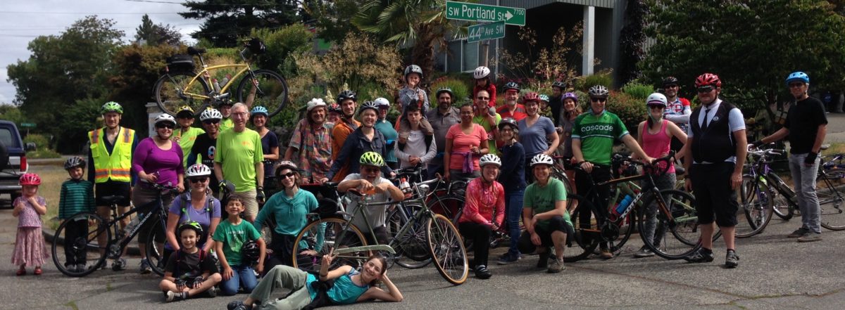
We had a great group of 35 riders, from age 2 to 70-something and everything in between. All made it successfully from (SW) Seattle (Street) to (SW) Portland (Street) in about one hour. After a little celebrating and socializing at Portland, we rode back via California to Alaska for a big celebration at the Summerfest!
Good especially to have several adult riders who were just getting back on a bike after many years of not riding. Some strong youth riders, too!
The project is in early stages of design and outreach, so this is a good time for input. We’ll have this on our July 11 meeting agenda, and may have SDOT staff attending. You are welcome to come. 6:30 pm at HomeStreet Bank, 41st SW & SW Alaska.
The Seattle Bicycle Master Plan has Avalon slated to get protected bike lanes as part of the city-wide network of bike routes. It’s a key route in and out of West Seattle, and like the other streets that are at angles to the grid, it provides the easiest grade up and over one of West Seattle’s steep ridges. We support this network of bike routes and the improvements that would make it comfortable and safe for many more people to ride than do so now. People of all ages and abilities, including parents carrying kids on bikes, and people well past their racing days.
We really want to have bike routes that work for commuters to downtown, and also for kids, families, older riders who have a hard time on steep grades or in busy traffic. At the same time, we want vital local business districts like Luna Park’s in our neighborhoods. We want to be able to walk, ride bikes, take a bus or drive to places like The Shack, Duos, and Luna Park Cafe. There is need for customer car parking and truck deliveries to the little business district near Spokane that may or may not need a compromise on protected bike lane going downhill. We absolutely need the uphill protected bike lane, and there is room to do that on the west side without any loss of car parking. The car parking would move out from the curb to provide a “parking-protected bike lane.” On the east side, going downhill, there is no problem doing a protected bike lane most of the way down. We’d love to see the protected bike lane continue to Spokane, with a safe way to cross to the Alki Trail and to the West Seattle Bridge Trail. However, it might be necessary to do something else from Yancy to Spokane. We are open to other options that SDOT engineers might come up with for that stretch.
You may know that we were successful in getting a Neighborhood Street Fund grant for bike/ped improvements to the intersection at Spokane/Harbor/Avalon/Alki Trail. This is now in design and scheduled for construction next year. It will make that intersection a lot safer for westbound riders on the trail crossing to go up Admiral or turning left to go up Avalon. Also includes signage and bike-left-turn improvements at Manning, for the route down Admiral Way to Avalon.
This NSF project will tie into the Avalon paving project.
When trucks back up on East Marginal Way S, some drivers get impatient and decide the hell with anybody else.
This morning, lots of people commuting to downtown on bikes reported dangerous moves into the bike lane by autos, light trucks and heavy trucks. The white Ford pickup drove over half a mile in the bike lane, only to get stuck in traffic again. The silver-gray tractor with the eagle on the door drove in the bike lane and gravel shoulder at speed. The 22-wheel semi with the Maersk container mowed down new plastic post dividers while driving into the bike lane with bike riders close in front and close behind. Those plastic posts can’t take that impact. Neither can bike riders.
We need enforcement. SPD and Port Police advise us to call 9-1-1as soon as we see this behavior. We did, Still happening later in the morning, as shown in others’ video.
Lot’s of us use it to get to downtown, SoDo, Beacon Hill, points north and east. Ten times as many would ride if this couple miles was more comfortable and safe. Others would ride south of Spokane Street if there was a way.Planning is beginning to finally make that happen. Here’s the opportunity to weigh in when it makes the most difference! Please do!
Tree and hydrant obstructions. SDOT moved the trees. SPU has not moved the hydrants. Could this be made into a real multi-use trail, at least to S Hanford Street?
The Delridge Rapid Ride H-Line onlne open house is open for comment. Please comment! SDOT and Metro are offering two unacceptable choices for riding on Delridge. Participate and let them know in the last “essay” question that “NONE OF THE ABOVE” is the answer. We expect full implementation of the Bicycle Master Plan with protected bike lanes on Delridge.
Riding a bicycle to and through West Seattle can be challenging due to limited safety provisions for people on bikes, and many hills. Delridge Way Southwest is one of the few north-south connections through West Seattle (along with 35th and Fauntleroy). It is the only major connection for the eastern portion of West Seattle. Delridge Way connects the West Seattle Bridge on the north to White Center on the south, while providing access to other important destinations including the Delridge Library, Boren STEM K-8 school, Southwest Pool, Chief Sealth High School, Denny Middle School, and Westwood Village. It is the only reasonably flat and evenly graded valley route connecting these destinations.
Although the proposed RapidRide H line is promising in terms of overall transportation improvements, there must also be a protected bike lane on the full length of Delridge Way for the people who already use this corridor and ride bicycles, and more importantly, for people who would if it was safe.
Seattle’s Comprehensive Plan calls for much greater use of bicycles for transportation. The City’s Climate Action Plan goals depend upon a significant increases in bicycle use. We are not yet on track to meet the 2035 goals. The Seattle Bicycle Master Plan calls for protected bike lanes on Delridge to meet these transportation and climate action goals. Provisions for safe bike riding are by far the least expensive way to add capacity to our streets and absorb population growth without adding to traffic congestion. The public health and safety benefits are obvious.
Many parts of Delridge Way SW are very wide, especially the areas north of Kenyon St. to the West Seattle Bridge. These portions could readily include continuous protected bicycle lanes on both directions with minimal disruption to traffic, parking, or existing street trees. On the south portion of the corridor, especially south of Henderson St/Barton Pl, there again are wide streets that can accommodate bicycle infrastructure. We acknowledge that the few blocks immediately to the south of Kenyon St are narrow. We ask that on this short important stretch some parking be removed to provide, at a minimum, standard width bike lanes.
There are no viable alternative routes to Delridge. Members of West Seattle Bike Connections and Seattle Neighborhood Greenways spent considerable effort mapping and then attempting to ride potential alternative, parallel routes. Coming into West Seattle from the north, access to the existing Delridge-Highland Park greenway is immediately challenging because of the steep grade at Andover. Further south, there are multiple further challenges including extreme elevation changes near Sanislo elementary school and unsafe traffic conditions around Dumar. This Greenway, while immensely useful to residents on the east side of West Seattle, does not connect well to destinations in the valley (schools, library, community center, and shopping).
Delridge has the flattest, most even grades up the valley. Nothing “parallel” comes close.
The 26th Ave Greenway provides a valuable parallel route as far south as Juneau, but dead-ends beyond. A steep climb from Juneau along Croft Pl would allow connection to the Delridge-Highland Park Greenway, but the grade is too steep to meet the standards of an all ages, all abilities route. Once Delridge narrows at Kenyon, it is possible to cut over on the unpaved right-of-way at Elmgrove to 22nd. Continuing south on 22nd, there are two major unprotected crossings at Thistle and Trenton, ending at a set of stairs at Barton to reconnect to Delridge or continue south on 21st.
Given no reasonable alternative, Delridge itself requires protected bike lanes. The traffic lanes are wide, so despite recently lowered speed limits, many drivers still pass through the area at uncomfortable speeds for people on bikes. As the flattest route through this part of the city, it is the only logical connection to improve to increase bicycle use for transportation, especially with great connections to schools and other destinations.
City suggested alternate “parallel route”!
We supported the Move Seattle Levy that promised to improve Delridge as a multi-modal corridor. We ask that the City deliver on that promise. We ask that the City follow its plans, and make Delridge a Complete Street.
SW Elmgrove from Delridge to 22nd SW22nd could be OK if an unimproved right of way at Elmgrove was turned into a paved path, but then it ends in steps at Barton. OK for a route to Westwood Village, but does not connect to White Center by bike.
Saturday, come out for a couple of hours to support our friends at Luna Park! They supported us for our successful Neighborhood Streets Fund grant for ped/bike crossing improvements here.
For safety improvements at the intersections of SW Spokane/ Alki Trail/ Harbor Ave SW/ Avalon Way/ SW Manning. Ranked #1 in the city of the 12 projects awarded from the 40 proposals that made it through the District Council voting and SDOT vetting. Background here and SDOT evaluation here.
Ranked high because the need is so obvious for better crossing safety for people walking and riding bikes. And because under Jodi Connolly’s leadership, with Bill Gobie’s ideas, we worked put together a coalition with Tony Fragada and Alki Community Council, Luna Park Neighbors, Nucor Steel, and got support from David Whiting of Admiral Neighborhood Association and SW District Council, and worked with Luna Park businesses to make sure their needs are included. Thanks to Dongho Chang, SDOT Chief Traffic Engineer, for coming out to observe conditions and steer us in the right direction. Thank you to Joe Laubach and all members of the Move Seattle Oversight Committee for supporting this project!
Urbanist article here about all of the projects. Would be great to see more of them funded!
Neighborhood Street Fund Grants come up every three years, for projects in the $100-500K range. Year 1: selection. Year 2: design. Year 3: construction.
6:30 to 8:00 pm at HomeStreet Bank, 42nd Ave SW and SW Alaska Street
Let’s work together to improve conditions and enjoy bike riding in West Seattle. Proposed greenway routes along the central spines of WS are on the agenda, along with World Day of Remembrance, Fauntleroy,… Print: “The Politicians” by Jose Guadelupe Posada in 1890, Mexico.
Let’s keep our saints alive and riding este’ dia de los Muertos and election season.
 Saturday, August 26 at 9:30 AM – 12:30 PM


